Showing posts with label P2X2. Show all posts

Monday, March 3, 2014

Walking on Water : Site Conditions

Inevitably becoming the modern sequel to "Atlantis: A Lost World", Venice is undergoing a slow, but drastic, mutation because of it's unrequited (more or less) love and need for water

"Love at first sight" is an accurate cliche to attach to my experience of Venice. Although the gondolas, the sunsets, the pigeons, caught my attention, the thing that 'got me' was the flooding, the duality of the 'Campos' and the water/pedestrian relation. 

Properly titled Aqualta by Cloud Architecture Office, the flooding series initially got me interested in the idea of a 'functioning' flooded city, specifically how architecture would develop and adapt to the fluctuating context. Visiting somewhere like Venice, where aqualta renders become reality on a daily basis, was an incredibly inspiring moment for possibilities of new methods of inhabiting Venice.

Aqualta by Cloud Architecture Office:


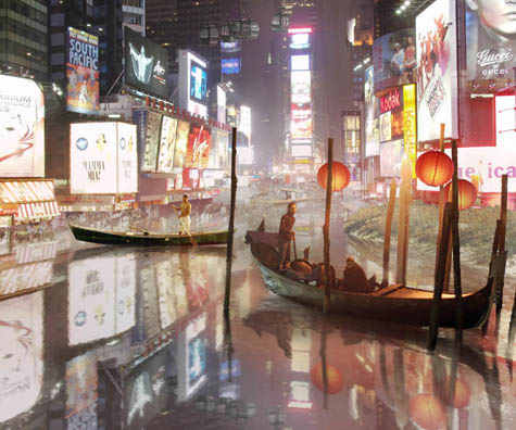
http://bldgblog.blogspot.it/2009/11/city-and-its-flooded-double_13.html

In addition to the rising tides, the duality of the 'Campos' as being a water collection site as well as an inhabitable open spot in a city of condensed living, excited me to explore the possibilities of these qualities in a possible architecture of Venice. The historical value behind the functionality of these sites allow for present translations to become tectonic moments. 

Ultimately, the equation of living in Venice attracted me the most. Pedestrian ± water = life. Water as being the main coefficient of pedestrian activity is amazing and better yet an opportunity for architecture to insert itself into daily life: Pedestrian ± (water x architecture) = life

Allora, this leads to the question:  "What am I doing in Venice". I want to put the people in the water. I have the impression that there is a unspoken anxiety of the water; people try to avoid it at all cost, although they depend on it. So, my proposal is to provide anxiety therapy by refocusing on water through different lenses by introducing an architecture that enters the water and allows for pedestrians to enjoy rather than avoid . To attempt this, the architecture will be programmed as a water recreation/resource facility : a public pool in the canal, a water reclamation site, and a bridge. 

Precedents:
Living in such proximity to water, I can imagine the fantasizing though of jumping in, especially in the summer. Such fantasy is similar to the one in NYC: +pool is attempting to give people the opportunity to enjoy water in new ways:

  http://www.pluspool.org/pool/

Also, the thought of blending pedestrian use and water is something that plays a big role in the proposal for a portion of 'the bridge': 

To be continued...


Final Proposal:


Restricted Pedestrian Activity


Incision into Fabric


Bridging Barriers  

Sketch Section of Depressed Floor

Colonnade 


Flux of Water Walkway 


Flux of Water Walkway 


 Water Walkway / Pool
AXO of Systems

AXO of Systems withing Context


Flux of Water Walkway : Low Tide 


Flux of Water Walkway : Aqualta


Tuesday, February 11, 2014

"Architecture", not architecture: the bridge does not insert into a place, it changes a place.

Architectural Typology vs Behavioral Typology: imagined & designed architectures


drivers: moments of pause (articulating private & public trajectories)


constituents: facades, landings, celebration of tectonics.


Monday, February 10, 2014

Angle on Venice: Renovation over Restoration

My research on Venice is focused on the ongoing discussions regarding tourism and the future development of the city. Venice cannot develop as most other cities because it's economy depends so heavily on the 22 million tourists that come to the city annually (a growing number) that value is almost completely derived from visitors. This means that any development of the city is made with visitors in mind instead of the less than 500,000 residents. This is problematic because Venice's visiting population is peculiar in that almost all of those visitors come only for one day and spend little money, if any, using the city as a 'free theme park.' This is hindering the development of a Venice for residents in the center mainly because funds are used for the restoration of older buildings whose only purpose is to draw tourists but no longer contribute to the fabric of the city programmatically. The discussion seems to be diverted into 2 plausible futures:
  1. Venice accepts that the visitors are more valuable than the residents and proceeds to turn itself into a museum city where residents are moved out and workers are brought in every day to work selected shops; the idea of rebuilding a local culture and trades is given up and replaced with maintenance of the little that is remaining, or falsely imitating the trades that are historically expected. This way Venice can protect the art and architecture as a heritage site without competing with the needs of residents as well as visitors.
  2. Venetians retake the city after the number of visitors is deemed unsustainable. Certain sectors of the city remain 'outdoor museums' and are maintained for a now restricted number of visitors who must pay an entrance fee. Elsewhere in the center, buildings are renovated (not restored) and added onto in order to thrust Venetian life into a sustainable and economically viable future, with old trades restored and new trades started. 

On another note, here are some useful maps of the city that present canals and roads a little differently. Here's a link to the full PDF http://www.radicalcartography.net/venice.pdf. The authors were students in Venice when they made this, so I imagine they spent a lot of time figuring out the data in real time. The writing is pretty good too, they talk about the pedestrian point of view and how the situation in Venice could be applied elsewhere if you replace Canals with incidents like highways.

Just canals - Islands

Blocks, that can span several islands and disregard the need of canals.

How the two intersect.

Venetian and International Identity - Site Conditions


Originally I chose site three because my initial studies were on Monet's experience in Venice where he painted/mapped areas around the grand canal mapping the nature of experience and lighting. By creating a bridge going across the Rio de l'Arsenal I could begin to create framed views out to the San Giorgio Maggiore, emphasizing how Venice's small roads frame certain views, and allowing these views to capture the sunset or various views out to the Canal Grande.


I diagrammed the surrounding area of the site and began to map the different pockets of spaces that ran throughout the Rio de l'Arsenal. I found that the eastern side of the river had larger spaces with less openings to get through while the western side was of a smaller scale of buildings with various pockets leading you out to the rest of Venice.

General section of the areas I want to merge my bridge with the surrounding context.


The Venice Biennale is a contemporary art exhibition that takes places every even year. It takes place in the Giardini Park, but in 1980 the Aperto in the Arsenal was opened for younger artists not represented in the park. The Giardini has 30 permanent pavilions and 29 various temporary pavilions. Each pavilion represents a country. I am proposing a Venetian bridge that can house one of the countries that design a temporary pavilion, it begins to create this tension between the identity of Venice and the Identity of the pavilion's country. 

Belgian

Hungarian

Switzerland

Designed by Alvaro Siza

Croatia

Japan

British

Netherlands

Russia


United States!!!!!